
File:Europe in 1328.png

Original file (2,150 × 2,336 pixels, file size: 761 KB, MIME type: image/png)
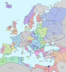
This image shows the state of Europe in the year 1328.
- Significance: w:Philip VI of France founds the w:Valois Dynasty after the death of King Charles IV of France, who has no sons to inherit.
The original image was released into the public domain ("I assert no proprietary interest in these materials but offer them freely for public use. You may copy them, reproduce them, or do whatever you wish with them. I hope that, whatever use you may make of them, they will prove of some value to you.")
Source: [1] [checked 16 Feb 2007- now a bad link, however lead to http://www.vlib.us/glaughead.html, and am querying for new url. FrankB 19:04, 16 February 2007 (UTC)]
I modified it using MS Word (essentially I traced the map details) making it much, much clearer and more attractive. Of course this image as well as the image it is based on is released into the public domain. Details modified also Dec. 26, 2018, according with H.-E. Stier (dir.), Grosser Atlas zur Weltgeschichte, Westermann 1985, (ISBN 3-14-100919-8), p. 71; Putzger historischer Weltatlas, Cornelsen 1990, (ISBN 3-464-00176-8); Georges Duby, Atlas historique, Larousse 1987, (ISBN 2-03-503009-9), André & Jean Sellier 'Atlas des Peuples La Découverte : Orient 1993, (ISBN 2-7071-2222-X), Claude Mutafian & Éric Van Lauwe, Atlas historique de l'Arménie, Autrement, coll. « Atlas / Mémoires », 2005 (ISBN 978-2746701007), p. 56-57.
| This work has been released into the public domain by its author, Lynn H. Nelson. This applies worldwide. In some countries this may not be legally possible; if so: Lynn H. Nelson grants anyone the right to use this work for any purpose, without any conditions, unless such conditions are required by law.
|
.png)
_en.png)
.png)
.jpg)
File history
Click on a date/time to view the file as it appeared at that time.
| Date/Time | Thumbnail | Dimensions | User | Comment | |
|---|---|---|---|---|---|
| current | 15:29, 12 August 2023 | | 2,150 × 2,336 (761 KB) | Gyalu22 | |
| 14:28, 7 August 2023 |  | 1,075 × 1,168 (114 KB) | Yuri V. | Novgorod Republic | |
| 01:22, 7 August 2023 |  | 1,075 × 1,168 (96 KB) | Yuri V. | Kingdom of Galicia–Volhynia 1199–1349, reverted to version as of 20:03, 7 November 2022 (UTC) | |
| 15:48, 16 November 2022 |  | 2,150 × 2,337 (116 KB) | Gyalu22 | Reverted to version as of 07:03, 14 July 2022 (UTC) | |
| 20:03, 7 November 2022 |  | 1,075 × 1,168 (96 KB) | Maxglig | Reverted to version as of 18:52, 26 December 2018 (UTC) | |
| 07:03, 14 July 2022 |  | 2,150 × 2,337 (116 KB) | Gligan1 | Original version restored | |
| 18:52, 26 December 2018 |  | 1,075 × 1,168 (96 KB) | Julieta39 | Details according with H.-E. Stier (dir.), ''Grosser Atlas zur Weltgeschichte'', Westermann 1985, (ISBN 3-14-100919-8), p. 71; ''Putzger historischer Weltatlas'', Cornelsen 1990, (ISBN 3-464-00176-8); Georges Duby, ''Atlas historique'', Larousse 1987, (ISBN 2-03-503009-9), André & Jean Sellier '''Atlas des Peuples'' La Découverte : ''Orient'' 1993, (ISBN 2-7071-2222-X), Claude Mutafian & Éric Van Lauwe, ''Atlas historique de l'Arménie'', Autrement, coll. « Atlas / Mémoires », 2005 (ISBN 978-2... | |
| 12:09, 24 December 2017 |  | 1,075 × 1,168 (101 KB) | Trey Kincaid | I've corrected Sicily, who was at that times an independent kingdom with Federico III as a king. | |
| 22:53, 27 April 2017 |  | 1,075 × 1,168 (87 KB) | Santasa99 | Rivers redrawn in blue, some info added and some corrections per Euroatlas - Historical Maps, [http://www.euratlas.net/history/europe/1300/index.html Euratlas Periodis Web - Map of Europe in Year 1300] | |
| 19:35, 10 May 2015 |  | 1,075 × 1,168 (120 KB) | Artemis Dread | Baia?! |
File usage
The following page uses this file:
Global file usage
The following other wikis use this file:
- Usage on an.wikipedia.org
- Usage on ar.wikipedia.org
- Usage on ast.wikipedia.org
- Usage on az.wikipedia.org
- Usage on ban.wikipedia.org
- Usage on ba.wikipedia.org
- Usage on be.wikipedia.org
- Usage on bg.wikipedia.org
- Usage on bs.wikipedia.org
- Usage on bxr.wikipedia.org
- Usage on ca.wikipedia.org
- Usage on cs.wikipedia.org
- Usage on cv.wikipedia.org
- Usage on da.wikipedia.org
- Usage on de.wikipedia.org
- Usage on el.wikipedia.org
- Usage on en.wikipedia.org
- Usage on en.wikibooks.org
- Usage on es.wikipedia.org
- Usage on et.wikipedia.org
View more global usage of this file.